Understanding the distinct differences between England, Great Britain, and the United Kingdom helps you avoid common geographical and political misconceptions.
This European region features a complex makeup where historical national borders do not always mirror the physical coastlines.
Breaking down the terminology lets you clearly differentiate between a single sovereign state, the individual nations that comprise it, and the broader archipelago.
Accurately categorizing these territories is essential for grasping their legal status, economic landscapes, and current independence movements.
The British Isles: Geographical Reality
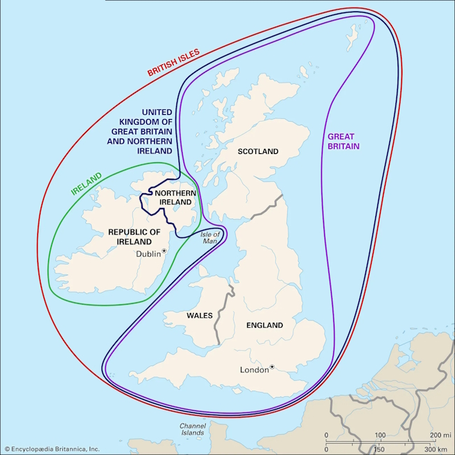
The map highlights:
-
Red: The British Isles
-
Green: The Republic of Ireland—geographically, the entire island of Ireland belongs to the British Isles archipelago, but politically, the Republic of Ireland is completely independent of the UK.
-
Purple: Great Britain (the island containing England, Scotland, and Wales)
-
Dark Blue: Northern Ireland
-
All Together: The United Kingdom—the entire country as a single sovereign state, which includes Northern Ireland.
Now, let’s look closer at these definitions.
The term “British Isles” refers purely to geography and covers the large archipelago off the northwestern coast of Europe, surrounded by the Atlantic Ocean and the North Sea. No single political authority governs this entire space today; it is strictly a cartographic concept. This broad physical region traditionally includes the following major landmasses:
-
The island of Great Britain, which stands as the largest island in Europe.
-
The island of Ireland, historically and physically distinct from its eastern neighbor.
-
Over six thousand smaller islands and island groups, including the Isle of Man, the Shetland Islands, the Orkney Islands, and the Channel Islands.
Separating geography from politics is vital here because the British Isles are home to two entirely separate sovereign states.
-
The first is the United Kingdom, which covers most of the archipelago.
-
The second is the Republic of Ireland, a completely sovereign country and a member of the European Union that does not answer to the British Crown.
Treating the entire archipelago as a single political unit is a significant factual error.
It is worth noting that the name of the archipelago itself occasionally sparks international debate. Government documents in the Republic of Ireland officially avoid the term “British Isles” due to deep historical ties to a colonial past. Instead, diplomatic communications between Dublin and London frequently use the neutral phrase “these islands,” emphasizing neighborly relations without implying territorial claims.
England: The Historical Core and Administrative Unit
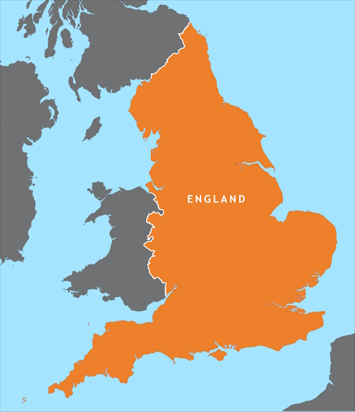
England is not a synonym for the entire country; it is just one of the four administrative and political nations that make up the unified state.
It covers the southern and central parts of the archipelago’s largest island, sharing land borders with Scotland to the north and Wales to the west. This is where London is located, serving historically as the permanent political, financial, and cultural hub for the rest of the Crown’s territories.
The common habit of calling the entire state England stems from its sheer demographic and macroeconomic dominance.
More than 80 percent of the sovereign country’s total population lives in this region, and it generates the lion’s share of the gross domestic product. The cultural reach of English traditions, the English language, and the common law system is so vast that it often unintentionally overshadows the distinct identities of neighboring regions on the global stage.
Despite its dominant position, England paradoxically holds the least amount of political autonomy in the modern governance system.
Unlike the other nations in the union, it lacks its own separate parliament or regional government with devolved powers. All domestic English laws are passed in Westminster by the UK Parliament, where lawmakers from all four nations hold seats, occasionally sparking intense debates over political fairness.
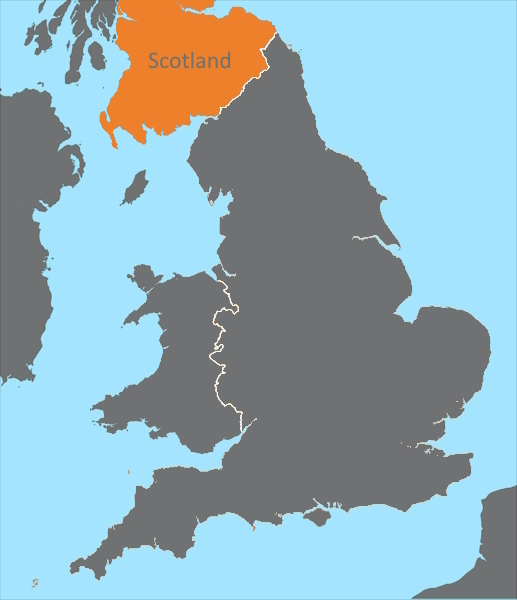
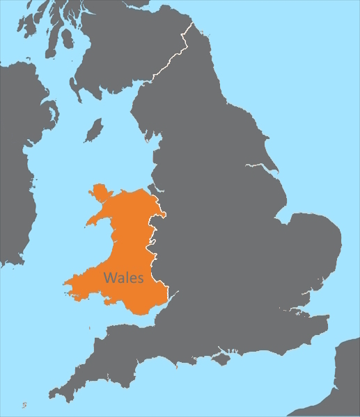
Great Britain: The Largest Island and Political Union
The term “Great Britain” primarily describes the largest island in Europe, located in the eastern portion of the archipelago.
From a political perspective, it represents the permanent union of three historic countries: England, Scotland, and Wales.
This name fundamentally excludes Ireland in any capacity and applies only to the landmass where these three nations have spent centuries building a shared economy and defense system.
The political formation of Great Britain as a single entity was a gradual process that unfolded across several major historical milestones:
-
The legal and military integration of Wales into the English administrative system during the sixteenth century.
-
The signing of the historic Act of Union in 1707, which permanently joined the parliaments of the sovereign nations of England and Scotland.
-
The creation of a unified economic and military powerhouse, allowing the new state to become a dominant force on the global stage.
It is critical to understand where Great Britain ends and the complete state begins. For a long time, this union of three nations did define the country’s borders, but the geopolitical map has evolved.
Today, when policymakers or economists speak specifically about Great Britain, they technically exclude Northern Ireland from their scope, focusing solely on the affairs of the main island.
The United Kingdom: A Sovereign State
The United Kingdom (abbreviated as the UK) is the official name of the independent country, a full member of the UN, and a recognized entity under international law.
Its full legal title is the “United Kingdom of Great Britain and Northern Ireland.” All international treaties are signed, civil passports are issued, and armed forces are maintained under the authority of this legitimate state.
This complex political entity took on its current borders in 1922 when the southern portion of the neighboring island broke away to establish the fully independent Republic of Ireland. Northern Ireland, comprising six counties of the historic province of Ulster, chose to remain under London’s governance following complex negotiations. Adding this territory to the three nations on the main island permanently established the four-nation union seen on maps today.
To truly understand how power and geographic ties are distributed within this complex state, it is helpful to look at its political hierarchy.
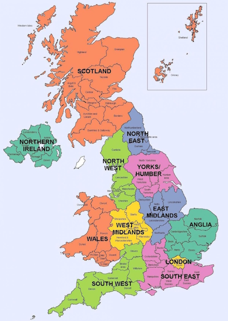
The table below maps out the structure of devolution and governance across the United Kingdom:
| Component Nation of the UK | Geographical Position | Local Parliament (Devolution) | Capital |
| England | South and center of Great Britain | None (governed directly by Westminster) | London |
| Scotland | North of Great Britain | Scottish Parliament (Holyrood) | Edinburgh |
| Wales | West of Great Britain | Welsh Parliament (Senedd) | Cardiff |
| Northern Ireland | Northeast of Ireland | Northern Ireland Assembly (Stormont) | Belfast |
Visas
Let’s clear up a few common myths on this topic.
A UK visa is valid across the entire United Kingdom (England, Scotland, Wales, and Northern Ireland), as well as the Isle of Man and the Channel Islands.
The independent Republic of Ireland requires a separate Irish visa because it is not part of the UK. The only exceptions are citizens of certain countries (such as China and India) who can enter Ireland on a short-term British visa through special initiatives like the British-Irish Visa Scheme (BIVS) or visa waiver programs.
There is a widespread myth that because Canada and Australia sit under the UK Crown, a UK visa is enough to visit them. While both nations recognize the British monarch (currently King Charles III) as their head of state, their visas and legal frameworks are entirely separate.
Canada and Australia are fully independent sovereign nations with their own immigration systems. A British visa grants zero entry rights to these countries, meaning you must apply for separate national visas or electronic travel authorizations, such as an eTA or eVisitor visa.
Overseas Territories
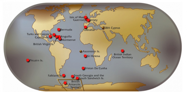
The British Overseas Territories consist of 14 territories scattered across the globe—ranging from Gibraltar and Bermuda to the Falkland Islands—that remain under British sovereignty but are not formally part of the United Kingdom.
They maintain their own local governments, legal systems, and, crucially, their own independent immigration systems.
A standard UK visa does not grant direct entry to these locations; you must obtain a specific permit for each territory or verify their individual immigration rules.
Geographically
Geographically, the United Kingdom is an inseparable part of Europe, situated right on the European continental shelf.
Culturally and politically, however, the British have historically maintained their distance from the mainland. This island isolation has fostered a unique national identity, reinforced by centuries of rivalry with continental powers like France and Germany, alongside its history as a former global empire.
For residents of the United Kingdom, the word “Europe” frequently refers to “the mainland” or “the Continent” as something external to themselves. Their departure from the European Union (Brexit) simply formalized this deep-seated cultural and geopolitical separation from the broader European project.
Analysis: Union Stability and Independence Outlook
In the twenty-first century, the unity of the United Kingdom faces unprecedented political challenges, led primarily by active Scottish independence movements.
The Scottish National Party (SNP) consistently campaigns to leave the UK, citing deep differences in economic goals and social policies. Although the region voted against independence in a 2014 referendum, the UK’s exit from the European Union (Brexit) fundamentally altered the political landscape; a majority of voters in the north wished to remain in the EU, sparking legally grounded demands for a second referendum.
The situation in Northern Ireland presents an even more intricate web of geopolitical tension, tied directly to shifting demographics.
For the first time since the administrative region was established, the Catholic population—which historically favors unifying with the Republic of Ireland—outnumbers the Protestant Unionist population loyal to the British Crown. The terms of the Good Friday Agreement legally permit a referendum on the border’s status (a Border Poll), and the rapid political rise of the Sinn Féin party makes the reunification of the island of Ireland a highly possible scenario.
Despite these strong regional shifts and national ambitions, an immediate breakup of the country remains unlikely due to the deep economic and institutional ties binding all four regions.
A shared financial system, the absence of internal customs borders, intertwined pension structures, and a single military force act as powerful anchors against hasty separation. London is expected to safeguard the historic union by offering further devolution—transferring more tax and legislative powers to local assemblies—gradually shifting the unitary state toward an asymmetric federation.
Welcome to Poznayu.com!
My name is Alex, and I founded this project together with a team of like-minded professionals. At Poznayu.com, we create in-depth reviews, explore fascinating facts, and share well-researched, reliable knowledge that helps you navigate complex topics with confidence.
Our mission is simple: to explain complicated ideas in clear, accessible language. We believe that high-quality information should be available to everyone. Every article we publish is designed to provide practical value, actionable insights, and trustworthy analysis you can rely on.
Join our growing community of curious readers. Your feedback matters — share your thoughts in the comments, ask questions, and suggest topics you’d like us to cover next.

